
Since 2001, satellites have recorded 10,245 hectares of tree cover lost across Pakistan. A quarter of it, 2,613 hectares, was in North Waziristan, a district with about 1 per cent of the country's trees. In August 2022, the floods covered 95 per cent of Jaffarabad, on Balochistan's border with Sindh. Satellites recorded the largest change of its kind in each district, and Table 1 sets both beside their provinces on the census and survey measures of energy, water and poverty.
| Indicator | North Waziristan | Khyber Pakhtunkhwa | Jaffarabad | Balochistan | Pakistan |
|---|---|---|---|---|---|
| HouseholdsCensus 2023 | 99,595 | – | 81,562 | – | – |
| Light from the gridper cent of households, 2023 | 52.6 | 79.9 | 74.6 | 57.1 | 84.0 |
| Light from a solar panelper cent of households, 2023 | 39.1 | 13.1 | 9.5 | 26.4 | 7.7 |
| Light from neitherper cent of households, 2023 | 8.3 | 7.0 | 15.9 | 16.5 | 8.2 |
| Cook on firewoodper cent of households, 2023 | 91.5 | 71.4 | 52.9 | 70.1 | 52.7 |
| Cook on gasper cent of households, 2023 | 0.9 | 22.6 | 13.8 | 17.9 | 37.8 |
| Improved drinking waterper cent of households, 2023, as PBS defines it | 68.7 | 82.2 | 48.3 | 71.4 | 91.9 |
| In multidimensional povertyper cent of people, 2019-20 | 69.7 | 53.0 | 73.9 | 72.7 | 52.7 |
| Travel time to a health facilityminutes by road, median resident | 74 | 20 | 24 | 92 | 17 |
| Under water at the 2022 flood peakper cent of district area | 0.1 | – | 94.6 | – | – |
| Cropped landper cent of land, 2020 | 2.5 | – | 84.2 | – | – |
North Waziristan
North Waziristan is one of Khyber Pakhtunkhwa’s merged districts, on the border with Afghanistan, with about 100,000 households in the 2023 census. In 2000, trees with a canopy of at least 30 per cent covered 10,458 hectares, about 2 per cent of the district. Figure 1 shows the loss recorded in each year since. Of the 2,613 hectares lost, 2,493 went between 2004 and 2011. Since 2012, the record shows 59 hectares.
The record cannot say why the trees went. It is built by classifying Landsat images pixel by pixel, and 87 per cent of the lost area was also marked as burned in the same year. A separate global model of the causes of tree loss attributes almost all of it to logging, so the two measures of cause disagree. The years of loss were also years of militancy and military operations in the district, but neither dataset connects the two. The satellites also count only stands that were cleared. Thinning and cutting for fuel do not register, so 2,613 hectares is a floor on the loss, not a measure of it.
The census records how households use fuel. Nine in ten cook on firewood, against seven in ten across Khyber Pakhtunkhwa, and one in a hundred cooks on gas. The census does not ask where the wood comes from, so it cannot be linked to the loss in Figure 1. For light, half of households use the grid and four in ten a solar panel, three times the provincial share. The census records the source of light, not the hours of supply. Seven in ten people were poor in 2019-20, against about half in the median district of the province. The median resident is 74 minutes by road from a health facility, against 20 minutes in the median district.
Jaffarabad
Jaffarabad lies on the canal-irrigated plain of eastern Balochistan. In 2020, 84 per cent of its land was cropped at least once in four years, against 3 per cent in North Waziristan. Figure 2 shows how much of the district was under water in each satellite observation of the 2022 floods. In the last week of August, 1,608 of its 1,701 square kilometres were flooded, and an estimated 89 per cent of its people lived in the flooded area. Water still covered 8 per cent of the district in mid-January 2023. Jacobabad, Larkana and Shikarpur, all in Sindh, are the only other districts that were more than 90 per cent under water in any observed week.
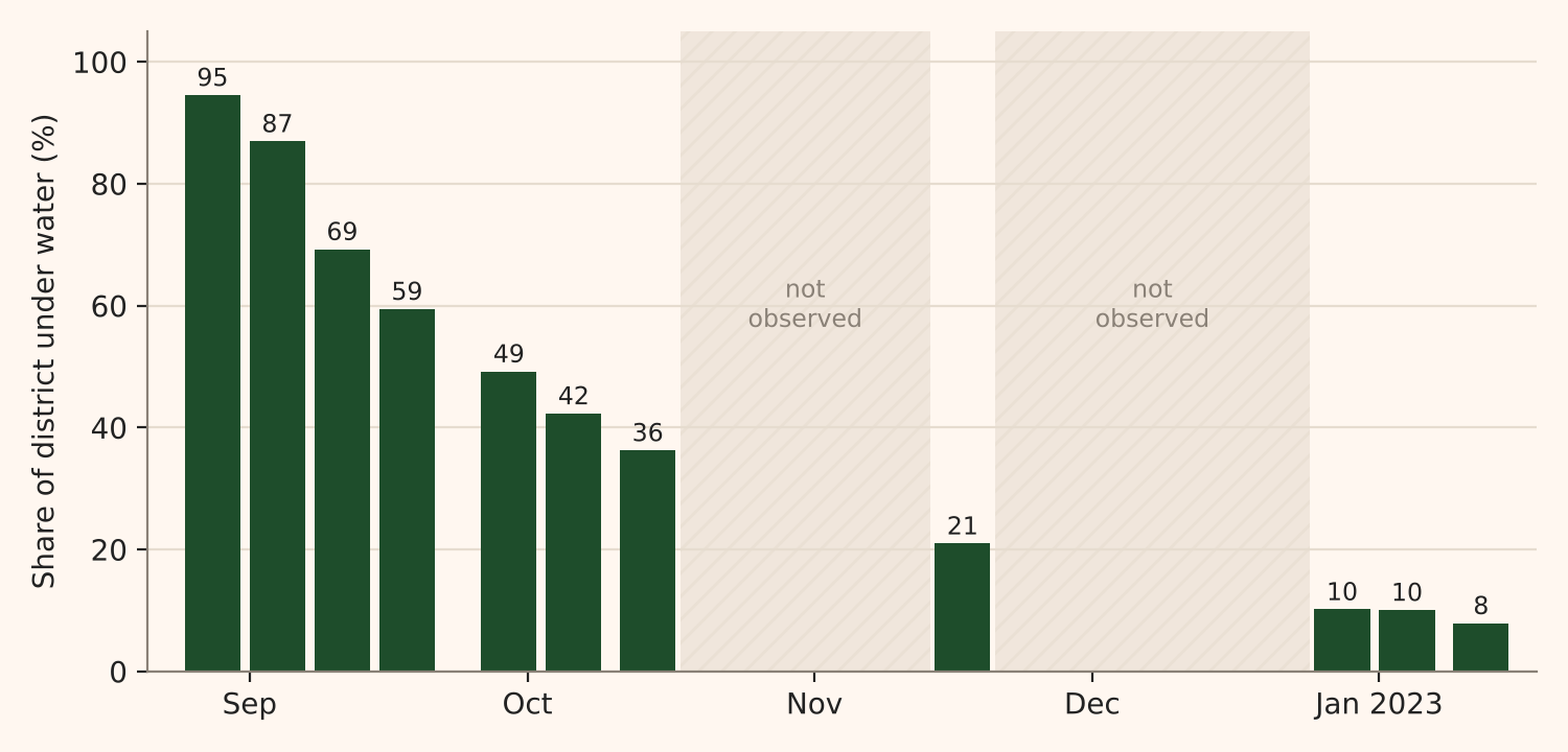
The crop statistics report Jaffarabad together with neighbouring Sohbatpur. Their rice harvest in 2022-23 was 28 per cent of the average of the three years before the floods. The next year it was 104 per cent. Wheat, sown after the water drained, did not fall (102 per cent of the average). A harvest that recovers is not the same as households that recover, and the crop record does not show debt, lost livestock or damaged homes.
FAO's household surveys come closer. They ask rural households eight questions about running short of food, from worrying about it to going a whole day without eating, and count a household as moderately or severely food insecure from its answers. When about 250 households in Jaffarabad were surveyed in February and March 2023, 85 per cent were moderately or severely food insecure, against 51 per cent in the median district of the 43 surveyed. Two in five were severely food insecure. The survey returned in November 2023 to January 2024, more than a year after the peak of the floods. By then 77 per cent were moderately or severely food insecure, the highest share of the 47 districts surveyed, and 37 per cent severely, more than twice the share in any other district.
Jaffarabad is better connected than most of Balochistan. Three in four households light from the grid, against 57 per cent across the province, and the median resident is 24 minutes from a health facility, against 92 minutes in the median district. Its drinking water is worse: by PBS's own definition, 48 per cent of households have an improved source, against 71 per cent in the province. Before the floods, 74 per cent of people were poor, close to the median district of Balochistan.
What the records cannot show
The satellite records date both losses precisely: North Waziristan's trees between 2004 and 2011, Jaffarabad's land from August 2022 to January 2023. They say nothing about who bore the loss. In both districts, seven in ten people were poor on the 2019-20 measure. For Jaffarabad, FAO's surveys show that most households were still short of food more than a year after the water receded, and the same surveys can show who lost crops, livestock and income. For North Waziristan, no comparable survey covers the years when the trees were lost.